DOI
License
Publication date
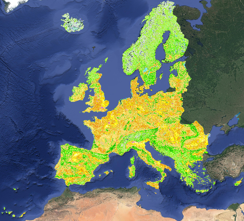
Probability and uncertainty maps of 43 CORINE land use / land cover classes in Europe, namely:
- 111 - Continuous urban fabric;
- 112 - Discontinuous urban fabric;
- 121 - Industrial or commercial units;
- 122 - Road and rail networks and associated land;
- 123 - Port areas;
- 124 - Airports;
- 131 - Mineral extraction sites;
- 132 - Dump sites;
- 133 - Construction sites;
- 141 - Green urban areas;
- 142 - Sport and leisure facilities;
- 211 - Non-irrigated arable land;
- 212 - Permanently irrigated arable land;
- 213 - Rice fields;
- 221 - Vineyards;
- 222 - Fruit trees and berry plantations;
- 223 - Olive groves;
- 231 - Pastures;
- 241 - Annual crops associated with permanent crops;
- 242 - Complex cultivation patter;
- 243 - Land principally occupied by agriculture with significant areas of natural vegetation;
- 244 - Agro-forestry areas;
- 311 - Broad-leaved forest;
- 312 - Coniferous forest;
- 313 - Mixed forest;
- 321 - Natural grasslands;
- 322 - Moors and heathland;
- 323 - Sclerophyllous vegetation;
- 324 - Transitional woodland-shrub;
- 331 - Beaches, dunes, sand;
- 332 - Bare rocks;
- 333 - Sparsely vegetated areas;
- 334 - Burnt areas;
- 335 - Glaciers and perpetual snow;
- 411 - Inland marshes;
- 412 - Peat bogs;
- 421 - Salt marshes;
- 422 - Salines;
- 423 - Intertidal flats;
- 511 - Water courses;
- 512 - Water bodies;
- 521 - Coastal lagoons;
- 522 - Estuaries.
Files are named according to the following naming convention, e.g:
- lcv_landcover.111_lucas.corine.eml_p_30m_0..0cm_2020_eumap_epsg3035_v0.2.tif
with the following fields:
- theme: e.g. lcv,
- land use / land cover class: e.g. landcover.111,
- estimation method: e.g. lucas.corine.eml,
- variable type: e.g. p ( = class probability),
- resolution in meters e.g. 30m,
- reference depths (vertical dimension): e.g. 0..0cm,
- reference period: e.g. 2020,
- reference area: e.g. eumap,
- coordinate system: e.g. epsg3035,
- data set version: e.g. v0.2.
This naming convention makes it easy to identify the file names of probability and uncertainty maps for each land use / land cover class:
- lcv_landcover.111_lucas.corine.eml_p: Probability of class 111: Continuous Urban Fabric
- lcv_landcover.311_lucas.corine.eml_md: Model Disagreement of class 311: Broad-leaved forest
Code on structure and applications of the dataset is available on GitLab
European coverage, 30m resolution, Cloud Optimized Geotiff, https download
EPSG:3035
Witjes, Martijn; Parente, Leandro; van Diemen, Chris; Hengl, Tomislav; Landa, Martin; Brodský, Lukáš; Halounova, Lena; Križan, Josip; Antonić, Luka; Ilie, Codrina Maria; Craciunescu, Vasile; Kilibarda, Milan; Antonijevic Ognjen & Glusica, Luka. (2022). Continental Europe land cover mapping at 30m resolution based on CORINE and LUCAS samples [Data set]. Zenodo. https://doi.org/10.5281/zenodo.4725429
The datasets can be accessed on Zenodo. Check the Related identifiers section on the right to access the individual classes.
					gdalinfo /vsicurl/http://s3.eu-central-1.wasabisys.com/eumap/lcv/lcv_landcover.hcl_lucas.corine.rf_p_30m_0..0cm_2019_eumap_epsg3035_v0.1.tif lcv_landcover_amsterdam.tif

# Driver: GTiff/GeoTIFF
# Files: /vsicurl/http://s3.eu-central-1.wasabisys.com/eumap/lcv/lcv_landcover.hcl_lucas.corine.rf_p_30m_0..0cm_2019_eumap_epsg3035_v0.1.tif
# Size is 188000, 151000
# Coordinate System is:
# PROJCRS["ETRS89-extended / LAEA Europe",
#     BASEGEOGCRS["ETRS89",
#         DATUM["European Terrestrial Reference System 1989",
#             ELLIPSOID["GRS 1980",6378137,298.257222101,
#                 LENGTHUNIT["metre",1]]],
#         PRIMEM["Greenwich",0,
#             ANGLEUNIT["degree",0.0174532925199433]],
#         ID["EPSG",4258]],
#     CONVERSION["Europe Equal Area 2001",
#         METHOD["Lambert Azimuthal Equal Area",
#             ID["EPSG",9820]],
#         PARAMETER["Latitude of natural origin",52,
#             ANGLEUNIT["degree",0.0174532925199433],
#             ID["EPSG",8801]],
#         PARAMETER["Longitude of natural origin",10,
#             ANGLEUNIT["degree",0.0174532925199433],
#             ID["EPSG",8802]],
#         PARAMETER["False easting",4321000,
#             LENGTHUNIT["metre",1],
#             ID["EPSG",8806]],
#         PARAMETER["False northing",3210000,
#             LENGTHUNIT["metre",1],
#             ID["EPSG",8807]]],
#     CS[Cartesian,2],
#         AXIS["northing (Y)",north,
#             ORDER[1],
#             LENGTHUNIT["metre",1]],
#         AXIS["easting (X)",east,
#             ORDER[2],
#             LENGTHUNIT["metre",1]],
#     USAGE[
#         SCOPE["unknown"],
#         AREA["Europe - LCC & LAEA"],
#         BBOX[24.6,-35.58,84.17,44.83]],
#     ID["EPSG",3035]]
# Data axis to CRS axis mapping: 2,1
# Origin = (900000.000000000000000,5460010.000000000000000)
# Pixel Size = (30.000000000000000,-30.000000000000000)
# Metadata:
#   1=111 - Urban fabric
#   10=212 - Permanently irrigated arable land
#   11=213 - Rice fields
#   12=221 - Vineyards
#   13=222 - Fruit trees and berry plantations
#   14=223 - Olive groves
#   15=231 - Pastures
#   16=311 - Broad-leaved forest
#   17=312 - Coniferous forest
#   18=321 - Natural grasslands
#   19=322 - Moors and heathland
#   2=122 - Road and rail networks and associated land
#   20=323 - Sclerophyllous vegetation
#   21=324 - Transitional woodland-shrub
#   22=331 - Beaches, dunes, sands
#   23=332 - Bare rocks
#   24=333 - Sparsely vegetated areas
#   25=334 - Burnt areas
#   26=335 - Glaciers and perpetual snow
#   27=411 - Inland wetlands
#   28=421 - Maritime wetlands
#   29=511 - Water courses
#   3=123 - Port areas
#   30=512 - Water bodies
#   31=521 - Coastal lagoons
#   32=522 - Estuaries
#   33=523 - Sea and ocean
#   4=124 - Airports
#   5=131 - Mineral extraction sites
#   6=132 - Dump sites
#   7=133 - Construction sites
#   8=141 - Green urban areas
#   9=211 - Non-irrigated arable land
#   AREA_OR_POINT=Area
# Image Structure Metadata:
#   COMPRESSION=DEFLATE
#   INTERLEAVE=BAND
# Corner Coordinates:
# Upper Left  (  900000.000, 5460010.000) ( 55d57'42.48"W, 56d18' 4.91"N)
# Lower Left  (  900000.000,  930010.000) ( 23d55'13.07"W, 24d32' 8.64"N)
# Upper Right ( 6540000.000, 5460010.000) ( 61d 5'51.71"E, 64d25' 1.96"N)
# Lower Right ( 6540000.000,  930010.000) ( 32d31' 8.79"E, 28d26'13.69"N)
# Center      ( 3720000.000, 3195010.000) (  1d18'47.59"E, 51d32'35.92"N)
# Band 1 Block=1024x1024 Type=Byte, ColorInterp=Gray
#   NoData Value=0
#   Overviews: 94000x75500, 47000x37750, 23500x18875, 11750x9438, 5875x4719, 2938x2360, 1469x1180, 735x590