DOI
Authors
License
Publication date
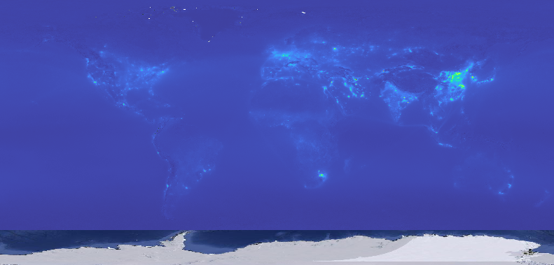
Tropospheric Nitrogen Dioxide Density monthly median value May 2018 – November 2022. Derived using the eumap package in Python. We derived three standard statistics: (1) 10th percentile (p10), median (m), and 90th percentile (p10). Scale is 0.1. Antarctica is not included.
All files internally compressed using "COMPRESS=DEFLATE" creation option in GDAL in Cloud Optimised GeoTiff (COG).
File naming convention:
- no2 = variable: nitrogen dioxide (µmol m-2),
- s5p.l3.trop.tmwm= determination method: Copernicus Sentinel-5P product, level 3, tropospheric, temporal moving window median
- p10/p50/p90 = aggregation/statistics method: 10th/50th/90th percentile,
- 2km = spatial resolution / block support: 2 km,
- a = vertical reference: above ground,
- start date_end date (i.e. 20180501_20180531) = time reference: from start date to end date
- go = bounding box: global land without Antarctica
- epsg.4326 = ESPG code: epsg.4326
- v20221219 = version code: creation date 20221219
For more info about the s5p NO2 product see: Copernicus Sentinel-5P Tropospheric Nitrogen Dioxide
Global coverage, 2km resolution, Cloud Optimized Geotiff
EPSG:4326
Yu Feng Ho, Tomislav Hengl, & Leandro Parente. (2022). Sentinel-5P Tropospheric Nitrogen Dioxide Density at 2 km from 2018-05 to 2022-11 Monthly Aggregation (Version 1) [Data set]. Zenodo. https://doi.org/10.5281/zenodo.7464099
The datasets can be accessed on Zenodo
					gdalinfo /vsicurl/https://s3.openlandmap.org/arco/no2_s5p.l3.trop.tmwm_p50_2km_a_20180501_20180531_go_epsg.4326_v20221219.tif

# Driver: GTiff/GeoTIFF
# Files: /vsicurl/https://s3.openlandmap.org/arco/no2_s5p.l3.trop.tmwm_p50_2km_a_20180501_20180531_go_epsg.4326_v20221219.tif
# Size is 16383, 6798
# Coordinate System is:
# GEOGCRS["WGS 84",
#     DATUM["World Geodetic System 1984",
#         ELLIPSOID["WGS 84",6378137,298.257223563,
#             LENGTHUNIT["metre",1]]],
#     PRIMEM["Greenwich",0,
#         ANGLEUNIT["degree",0.0174532925199433]],
#     CS[ellipsoidal,2],
#         AXIS["geodetic latitude (Lat)",north,
#             ORDER[1],
#             ANGLEUNIT["degree",0.0174532925199433]],
#         AXIS["geodetic longitude (Lon)",east,
#             ORDER[2],
#             ANGLEUNIT["degree",0.0174532925199433]],
#     ID["EPSG",4326]]
# Data axis to CRS axis mapping: 2,1
# Origin = (-180.000000000000000,87.370000000000005)
# Pixel Size = (0.021972656250000,-0.021972656250000)
# Metadata:
#   AREA_OR_POINT=Area
# Image Structure Metadata:
#   COMPRESSION=DEFLATE
#   INTERLEAVE=BAND
#   LAYOUT=COG
# Corner Coordinates:
# Upper Left  (-180.0000000,  87.3700000) (180d 0' 0.00"W, 87d22'12.00"N)
# Lower Left  (-180.0000000, -62.0001172) (180d 0' 0.00"W, 62d 0' 0.42"S)
# Upper Right ( 179.9780273,  87.3700000) (179d58'40.90"E, 87d22'12.00"N)
# Lower Right ( 179.9780273, -62.0001172) (179d58'40.90"E, 62d 0' 0.42"S)
# Center      (  -0.0109863,  12.6849414) (  0d 0'39.55"W, 12d41' 5.79"N)
# Band 1 Block=512x512 Type=Int16, ColorInterp=Gray
#   NoData Value=-16000
#   Overviews: 8192x3399, 4096x1700, 2048x850, 1024x425, 512x213