This vacancy is closed
Application Deadline: 1st of November 2022
Possible start date: 1st of January 2023
Duration: 3+ years,
Job location: Agro Business Park 10, Wageningen
Bruto monthly salary: starting at €3.807 gross per month depending on experience
Job type: post-doctoral researcher
Fields: pedometrics, geocomputation, global datasets, environmental sciences, Earth observation, data science, high performance computing
Employer: OpenGeoHub foundation
Job description
OpenGeoHub foundation is a not-for-profit research foundation with headquarters at the Agro Business Park, Wageningen, the Netherlands. We aim to become world experts in producing global and regional spatial predictions of soil, vegetation, biodiversity and climatic variables. For this, we use high performance computing / optimisation and state-of-the-art machine learning.
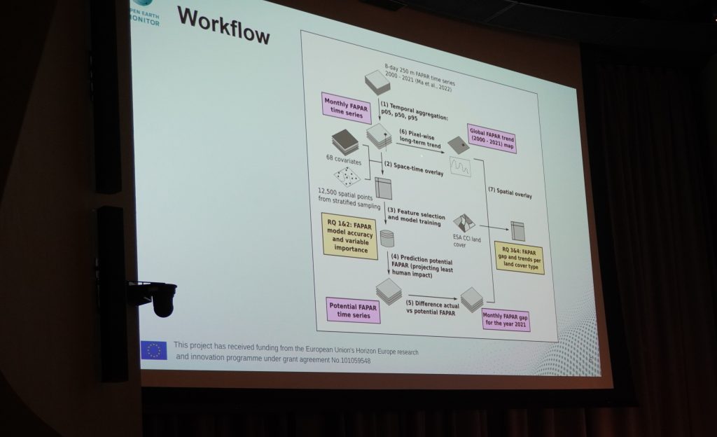
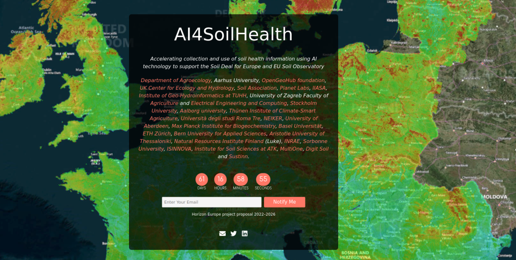
OpenGeoHub foundation is looking for a post-doctoral researcher in the field of pedometrics, geo-computation and geoinformatics (programming in R, Python, Bash, Julia and similar), specifically focused on using state-of-the-art geocomputing frameworks / algorithms and GIS software to help import, organize and model multivariate static and dynamic soil variables for the purpose of producing global and European datasets (Open Soil Data Cubes) either by running analysis, statistical modeling or by running process-based models. You would work for OpenGeoHub on current and future high profile European Commission-funded and other international projects where there is a need to develop new solutions for measuring and modeling soil and ecosystem variables, run geocomputing, optimize and automate modeling frameworks and deliver scientific outputs in a timely manner. You would primarily contribute to the Horizon Europe projects AI4SoilHealth (2023–2026) and Open-Earth-Monitor (2022–2026); also actively contribute to the www.OpenLandMap.org and EcoDataCube.eu data portals.
You would spend a significant amount of time innovating solutions to produce more accurate and easier to update spatial and spatiotemporal predictions of soil properties and classes, then report the results in research publications, meeting with senior researchers (weekly), and using our own computing center to optimize spatial analysis. You would also be encouraged to network with other researchers and groups of world leaders in their fields. OpenGeoHub works closely with University of Aarhus, Center for Ecology and Hydrology (CEH) UK, EU Soil Observatory at JRC (EUSO), IIASA (Geo-wiki.org), Wageningen University (Laboratory of Geo-information Science and Remote Sensing), EURAC Research, ETH (Tom Crowther’s Lab), The Woodwell Climate Research Center, Max-Planck-Institute for Biogeochemistry (Biogeochemical Integration Department), Institute for Geoinformatics (ifgi) / University of Münster, GFZ Helmholtz German Research Centre for Geosciences, GiLAB.rs, and many other organizations. Our clients / collaborating organizations also include: The Nature Conservancy, UNCCD, World Resources Institute, Conservation International and others.
Successful candidates will be encouraged / supported to apply for the 30% ruling which can lead to additional financial and other benefits.
“Join us in producing next-generation Open soil data to support large-scale land restoration projects and enabling landowners tracking their soil-health”
Your profile
Minimum requirements:
You have a PhD degree in the field of pedometrics and/or environmental science and/or geoinformatics; combined with a background in GIS, geocomputation, and/or statistics.
- You have a PhD degree in the field of pedometrics and/or environmental science and/or geoinformatics; combined with a background in GIS, geocomputation, and/or statistics.
- You are independent in running geocomputing in R and/or Python and/or Bash.
- You have experience with predictive soil mapping using Machine Learning in modeling frameworks such mlr3, scikit-learn, tidymodels and similar.
You are competent at, and enjoy developing analytical solutions, producing value-added datasets, writing up and reporting research / results of experiments. - You know how to automate benchmarking and optimize geocomputing to save computing costs without losing on accuracy.
- You have experience working with soil measurements based on laboratory methods and/or soil spectroscopy.
- You are fluent in English.
Note: Residence permit for a researcher under Directive (EU) 2016/801 applies
INFORMATION AND APPLICATION
Questions:
Questions regarding this position can be directed to Tom Hengl, email: tom.hengl@opengeohub.org
Applications, including: (1) a CV, (2) a statement of your interest and vision, and (3) a self-assessment based on the minimum requirements, should be uploaded via this link. Please prepare all documents as a PDF before starting the application.
Our offer:
We offer a full-time position for 3 years, with possible extension, within a very stimulating international innovation and research environment aimed at solving global and regional environmental problems at large scales. You will work in a dynamic work environment with enthusiastic colleagues usually from a variety of countries.
- Salary starting at €3.807 gross per month depending on experience;
- A holiday allowance of 8% of the gross annual salary;
- Minimum of 29 holidays if in full-time employment;
Professional and personal development programs.
We are a truly international research institute promoting equal opportunities and especially focused on enabling female researchers. We strongly encourage a high degree of responsibility and independence, while collaborating with other colleagues. Flexi-hours and occasional remote working are also possible upon agreement with the OpenGeoHub Management Board.