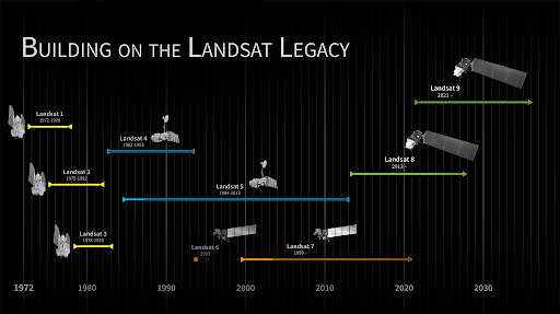
Back

Geo-harmonizer project: making new seamless spatial layers for the continental EU

OpenGeoHub has started in 2019 an Innovation and Networks Executive Agency (INEA) co-funded project called “Geo-harmonizer: EU-wide automated mapping system for harmonization of Open Data based on FOSS4G and Machine Learning”. The project homepage is https://opendatascience.eu. We have published in March 2020 the Implementation plan and are now working on new data-sets including:

  • New ensemble model of Digital Terrain for the whole continental EU at 30 m resolution,
  • New complete land cover maps with uncertainties,
  • New potential natural vegetation maps for target forest species,
  • New higher resolution soil property maps,
  • and several other layers,

We typically use multiple input data sets, then train Ensemble Machine Learning models and produce predictions that are complete, consistent and fully harmonized. This way we help fill in the gaps and reduce differences between environmental variables across EU borders. Majority of the output products we produce including the software will be released under Open Data license / Open Source software, so stay tuned for updates and new releases.

Spread the love